Aerial Photography

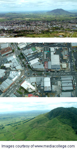
Aerial photography means any type of photography taken from a camera that is not attached to the ground in any way. Photographs may be taken by a human photographer or remote controlled system.
Aerial photographs can be taken using any of the following...
- Fixed-wing aircraft
- Helicopter
- Balloon, blimp or dirigible
- Kite
- Skydiver
- Rocket
Skills & Techniques
Anyone can point a camera through an airplane window and take interesting shots, but for the serious or professional photographer there are some issues to address and skills to acquire, including:
- Getting the right perspective: Many aerial photos are taken at an angle other than straight down, so the perspective will depict closer objects as being larger than distant ones. This is not desirable for certain applications such as mapping. The problem can be addressed by editing the photo with perspective-correcting tools. Photos altered in this way are known as orthophotos.
- Stitching: It is a very common requirement to stitch multiple aerial photographs together, especially for any type of mapping work.
- Registration: This is a specialist technique of mapping features in aerial photographs to useful maps.
Photographs taken early or late in the day provide more shadows which can make it easier to distinguish objects and contours.
To minimise vibration:
- Use a high ISO setting and fast shutter speed.
- Use a wide lens (telephoto lenses magnify vibration).
- If your camera has a good motion stabilizer, use it.
- Don't brace yourself against the aircraft, this will pick up more vibration.
- In professional situations you may be able to use a gyro mount.
Inexperienced photographers may find the aerial environment unfamiliar, so it's a good idea to use a digital camera with lots of memory. Preview and review photos, especially the first few, to make sure things are working as expected. If necessary, concentrate on framing and adjust exposure later using editing software.
Airplane vs Helicopter
A common question for new aerial photographers is "Which is best — a plane or helicopter?"
The advantage of a plane is likely to be that it's easier to find one, and perhaps cheaper as well. The main disadvantage is the wings or struts which get in the way. Also, a plane can't hover or fly slowly, and aerospace laws may forbid low-flying. If you do use a plane, high-wing Cessnas are considered a good option due to their slow speed and large windows.
Helicopters have a number of advantages including the ability to hover and move slowly, fly at low altitudes, and remove the door for better movement and clearer photographs.
Privacy and Legality
In most jurisdictions taking photographs of private property from the air is legal, as it falls under the provision that allows photographs of anything viewable from a public place. Government or military locations sometimes have their own laws.
In the 21st Century some people have challenged this legal right, especially with the popularisation of services like Google Earth. Some countries are reconsidering their position and changes are possible.

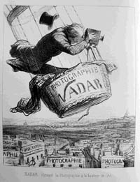
Lithograph by Honore Daumier, Le Boulevard, 1862.
History
Aerial photography was pioneered by French photographer and balloonist Nadar (real name Gaspard-Félix Tournachon, 1820 –1910) in the 1850s when he took photos of Paris from a hot air balloon.
Military applications were recognized and developed in World War I.
Over the years aerial photography became an important aspect of environmental studies, cartography, archeology, town planning, commercial development and many other fields.
From the 1960s space-based aerial photography has provided scientific data about the Earth, Moon and other celestial bodies.